


Ukrainian F-16 fighter jet crashes during combat mission
01:11
| Home page Gallery |
|
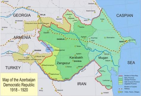
The map below, dating back to 1918–1919, was created by Great Britain.
Axar.az reports historian Zaur Aliyev, who shared the map, made these remarks.
He pointed out that the map includes parts of Azerbaijan’s territory, such as Zangezur, as well as significant portions of Goycha and Daralayaz.
What stands out most on the map is that the area south of the Araz River is also labeled as Azerbaijan. At that time, the Qajar dynasty, a Turkish ruling family, controlled what is now Iran.
It's important to note that in 1918, following the Ottoman Empire's defeat in World War I, plans were made for its division, which included the loss of Kars.


|
Date
2025.04.18 / 13:30
|
Author
Axar.az
|